Driving Distance & Time from NYC to San Antonio, TX
Learn the full 2026 cost of driving from NYC to San Antonio, TX, including fuel expenses, tolls, rest stops, road conditions, parking, and essential budget tips for this long-distance route.
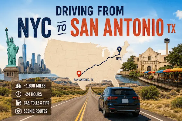
Driving from New York City to San Antonio, Texas is a long North-to-South cross-country journey covering 1,760 to 1,880 miles, depending on which interstate you select. The fastest, most reliable route combines I-78 → I-81 → I-40 → I-30 → I-35, a popular corridor that avoids the heaviest I-95 traffic and delivers smooth highway mileage through the Appalachian region and the American South.
The total driving time ranges from 27 to 31 hours, although the majority of travelers spread the trip across 3–4 days for safety and comfort. Traffic out of NYC and through the Northeast can slow early progress, but once you cross Virginia and Tennessee, the route opens into long, efficient highway segments.
Key Points:
- Distance: 1,760–1,880 miles
- Drive time: 27–31 hours
- Smoothest route: I-81 → I-40 → I-30 → I-35
Total Cost of Driving This Route
The total cost of driving from NYC to San Antonio in 2026 ranges between $340 and $630, influenced by vehicle type, MPG, toll route usage, and fuel costs. Fuel makes up the majority of the cost, with tolls concentrated in the Northeast and nearly disappearing as you enter Southern states.
Key Points:
- Total cost: $340–$630
- Fuel = largest share of spending
- Tolls decrease after Pennsylvania
Fuel Cost Breakdown for Driving from NYC to San Antonio TX in 2026
Fuel costs are one of the biggest expenses when driving from NYC to San Antonio, TX in 2026. The road trip covers approximately 1,830 to 1,840 miles and typically requires 73 to 75 gallons of gasoline for a vehicle averaging 25 MPG. With U.S. gasoline prices averaging around $4.14 to $4.19 per gallon in June 2026, most drivers can expect to spend roughly $300 to $315 on fuel for a one-way trip. More fuel-efficient sedans may spend closer to $250 to $280, while larger SUVs and trucks can easily exceed $400 in fuel costs.
For budget planning, a practical fuel cost breakdown includes $300 to $315 for gasoline, based on current national averages, plus additional fluctuations caused by fuel prices in states along the route. Drivers traveling through Pennsylvania, Virginia, Tennessee, Arkansas, and Texas may find varying pump prices, but the total fuel budget for most vehicles remains near $300. For a round trip between NYC and San Antonio, expect fuel expenses of approximately $600 to $630, making fuel the largest transportation cost after vehicle depreciation and maintenance.
Using the 2026 nationwide average fuel price of $4.20 per gallon, here’s the estimated cost based on MPG and total distance (~1,820 miles):
| Vehicle MPG | Gallons Needed | Estimated Fuel Cost |
|---|---|---|
| 20 MPG | ~91 gallons | ~$382 |
| 25 MPG | ~73 gallons | ~$307 |
| 30 MPG | ~61 gallons | ~$257 |
| 50 MPG (Hybrid) | ~36 gallons | ~$151 |
Larger trucks and SUVs may surpass $400 in fuel cost, while hybrids dramatically reduce total expenses. EVs can complete the journey for approximately $70–$130 depending on charging rates.
Key Points:
- Fuel typically costs $257–$382
- Hybrids cut the cost by more than half
- Higher elevation areas slightly reduce MPG
Gas Prices Along the Route (Area-Wise Comparison)
The cost of gasoline varies significantly along the route from NYC to San Antonio, making it worthwhile to plan fuel stops strategically. In June 2026, drivers leaving New York can expect some of the highest fuel prices on the trip, with regular gasoline averaging about $4.47 to $4.51 per gallon. Prices remain relatively high in Pennsylvania at around $4.37 per gallon, while nearby Mid Atlantic states such as Virginia average approximately $4.01 per gallon. As you travel farther south and west, fuel costs generally decline, helping reduce the overall cost of the road trip.
A typical route through Tennessee, Arkansas, and Texas offers some of the most affordable fuel prices in the country. Tennessee averages about $3.79 to $3.87 per gallon, Arkansas around $3.83 to $3.89 per gallon, and Texas approximately $3.67 to $3.75 per gallon. This means drivers can often save $0.70 to $0.85 per gallon by filling up in Texas instead of New York. For a vehicle requiring 74 gallons of fuel for the entire 1,830-mile journey, timing major fill ups in lower-cost states could save $40 to $60 compared with purchasing all fuel in the Northeast.
| Area/State | Average Gas Price (2026) |
|---|---|
| New York (NYC Area) | $4.47–$4.51/gal |
| Pennsylvania | $4.37/gal |
| Virginia | $4.01/gal |
| Tennessee | $3.79–$3.87/gal |
| Arkansas | $3.83–$3.89/gal |
| Texas (San Antonio Area) | $3.67–$3.75/gal |
Key Points:
- Cheapest gas: Texas and Arkansas
- Most expensive: New Jersey & Pennsylvania
- Best refuel strategy: Fill up once in Tennessee, once in Texas
Mileage, Fuel Efficiency & Vehicle Type Impact
The long highway profile benefits efficient vehicles, as consistent speeds maintain optimal MPG. Large SUVs and trucks will use significantly more fuel, especially through the rolling elevations of Virginia and Tennessee. Fully-loaded vehicles may lose 5–10% MPG across mountain stretches.
Key Points:
- Sedans and hybrids are most fuel-efficient
- Heavy vehicles see higher fuel consumption
- Long, flat Southern highways improve MPG
Toll Charges on the Route (State-Wise Details)
Toll charges for driving from NYC to San Antonio, TX are concentrated in the Northeast, particularly when leaving New York City and traveling through New Jersey and Pennsylvania. In 2026, drivers can expect to pay approximately $35 to $70 in total tolls depending on the route taken, vehicle type, and whether they use E-ZPass or pay by mail.
The largest toll expenses usually come from NYC bridges or tunnels, where passenger vehicles typically pay $14.79 to $19.55 with E-ZPass and up to $23.30 by mail. Pennsylvania Turnpike tolls also add a significant portion of the total trip cost, especially for drivers using the fastest interstate routes.
After passing through Pennsylvania, toll costs drop substantially. Most interstate highways through Virginia, Tennessee, Arkansas, and much of Texas are toll-free.
San Antonio itself has no major urban toll road network, unlike some parts of Austin, Dallas, and Houston. As a result, nearly all toll expenses occur during the first third of the journey, making toll budgeting relatively straightforward for travelers heading from NYC to San Antonio in 2026..
Tolls are light on this route after New Jersey and Pennsylvania. The majority of toll expenses occur early in the trip, while Southern states are mostly toll-free.
| Toll Region | Estimated Cost (2026) |
|---|---|
| NYC Bridges/Tunnels | $12–$18 |
| New Jersey Turnpike | $5–$8 |
| Pennsylvania Turnpike | $18–$32 |
| Maryland / Virginia | $3–$6 |
| Tennessee / Arkansas / Texas | $0 |
Total Estimated Tolls: $25–$55
Key Points:
- Tolls mostly limited to the first 300 miles
- Southward route becomes nearly toll-free
Parking Costs Upon Arrival
San Antonio is known for its affordable parking compared to most large U.S. cities. Downtown parking is moderately priced, while suburban areas often offer free parking.
| Area | Parking Cost |
|---|---|
| Downtown San Antonio | $10–$25/day |
| River Walk District | $10–$20/day |
| Suburban zones | Free or $5–$10/day |
Key Points:
- Overall low-cost parking city
- Suburban hotels often include free parking
Cost Comparison: Driving vs. Flying vs. Bus/Train
Driving from NYC to San Antonio, TX is often the best choice for travelers who value flexibility and are traveling with family, pets, or a large amount of luggage. In 2026, the total one-way driving cost is typically $400 to $650, including approximately $300 to $315 in fuel, $35 to $70 in tolls, and $60 to $250 for food, lodging, and vehicle wear.
The journey covers roughly 1,830 miles and takes about 27 to 30 hours of driving time, making it the most practical option for extended road trips and multi-stop travel. Travelers who split costs among multiple passengers can significantly reduce the per-person transportation expense. Without Driving: Train ($247–$600+).
| Mode | Cost | Time | Notes |
|---|---|---|---|
| Driving | $340–$630 | 3–4 days | Flexible, scenic, best for luggage |
| Flying | $140–$320 | 4 hours | Usually cheapest & fastest |
| Bus | $120–$190 | 35–40 hours | Budget but long |
| Train | $200–$350 | 36+ hours | Scenic but slow |
Key Points:
- Driving ideal for travelers bringing belongings
- Flying often the cheapest for solo passengers
Route Options & Road Conditions to Expect
Route 1 (Fastest & Smoothest): I-81 → I-40 → I-30 → I-35 → San Antonio
This route avoids East Coast congestion and offers consistent highway quality.
Route 2 (More Eastern): I-95 → I-10 → I-35
Longer and more traffic-heavy; not recommended for budget driving.
Road Conditions Overview:
- Appalachian region: rolling hills
- Tennessee to Texas: long, smooth highway segments
- Arkansas & Texas: modern, well-maintained corridors
Key Points:
- I-81 route best for comfort and fuel economy
- I-95 corridor more congested
Travel Time During Peak vs. Off-Peak Hours
Rush-hour traffic in NYC, New Jersey, Baltimore, and DC can add significant delays. Once past Virginia, traffic becomes lighter until Dallas and San Antonio metro zones.
Key Points:
- Avoid NYC morning/evening rush
- Dallas area congestion may add delays
- Off-peak departure saves time and fuel
Final Cost Summary of the Trip
Driving from NYC to San Antonio costs $340–$630 depending on vehicle efficiency, lodging, toll avoidance, and fuel planning. With strategic refueling and smart timing, this trip can be done affordably while enjoying scenic routes through the Appalachian Mountains, Tennessee Valley, and Texas landscapes.
Key Points:
- Total Cost: $340–$630
- Fuel Cost: $257–$382 for most vehicles
- Tolls: $25–$55
- Time Required: 27–31 hours
Quick Summary
| Topic | Summary |
|---|---|
| Distance | 1,760–1,880 miles |
| Total Cost | $340–$630 |
| Fuel Cost | $257–$382 |
| Tolls | $25–$55 |
| Parking | $5–$20/day |
| Best Route | I-81 → I-40 → I-30 → I-35 |
| Best Travel Time | 3–6 AM |
| Cheapest Fuel | Arkansas & Texas |
Federal Highway Administration (Travel & Road Conditions)
https://www.fhwa.dot.gov
FAQs
1. How long is the drive from NYC to San Antonio?
Around 27–31 hours of driving.
2. How much fuel is needed?
Most cars require 61–91 gallons depending on MPG.
3. Which state has the cheapest gas?
Texas and Arkansas.
4. Are tolls expensive on this route?
No — most tolls occur in the Northeast.
5. What is the best time to start driving?
Between 3 AM–6 AM to avoid East Coast traffic.